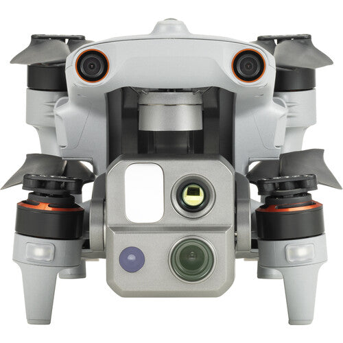
Autonomous Path Finding
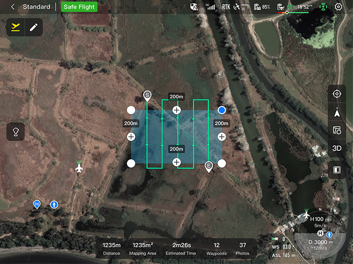
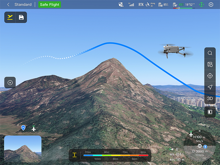
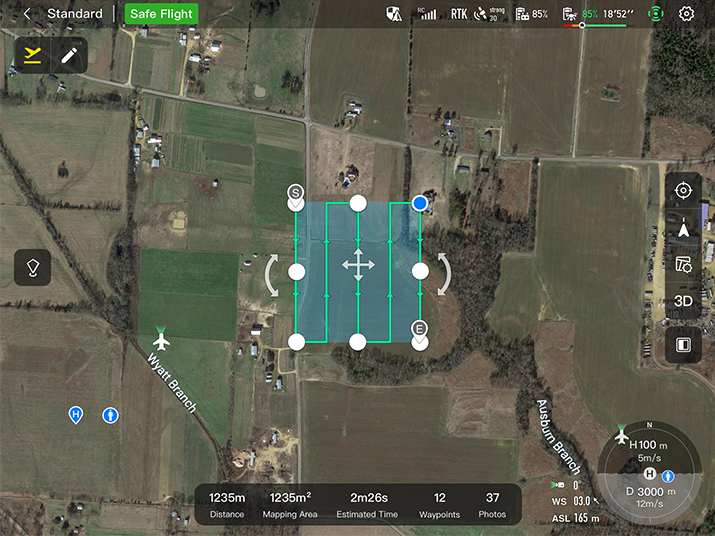
Autel's Autonomy Engine collects surrounding environmental data and plans 3D flight paths through complex environments such as mountains, forests, and buildings. Use cases include rapid 3D scene reconstruction, public safety overwatch, industrial inspection, and land surveying.
Navigation in GPS Denied Environment
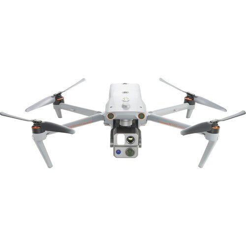
Advanced sensors allow the EVO Max 4T XE to navigate within hardened structures, underground, or in environments without GPS.
Accurate Object Identification and Tracking
Based on Autel's AI recognition technology, the EVO Max 4T can automatically identify and lock onto different types of targets such as heat sources, moving people, or vehicles and achieve high-altitude tracking and data collection for law enforcement.
Specifications:
Aircraft
|
Weight |
3.5 lbs (1600g, battery and gimbal included) |
|
Dimensions |
576*660*149 mm (folded, incl. propellers) 340*407*148 mm (folded, excl. propellers) 257*136*133 mm (unfolded, excl. propellers) |
|
Diagonal Wheelbase |
1.52 ft (464mm) |
|
Max Ascent Speed |
8m/s |
|
Max Descent Speed |
6m/s |
|
Max Horizontal Speed (windless near sea level) |
23m/s |
|
Max Service Ceiling Above Sea Level |
23000ft (7000m) |
|
Max Flight Time (windless) |
42 mins |
|
Max Hovering Time (windless) |
38 mins |
|
Max Wind Resistance |
27mph* *Takeoff and landing can withstand wind speeds up to 27 mph (12 m/s). |
|
IP Rating |
IP43 |
|
Max Tilt Angle |
35° |
|
Max Angular Velocity |
Pitch: 300°/s; Yaw: 120°/s |
|
Operating Temperature |
-4°F to 122°F (-20℃ - 50℃) |
|
Operating Frequency |
2.4G/5.2G*/5.8G/900MHz* |
|
Transmitter Power (EIRP) |
2.4GHz:<33dBm(FCC), <20dBm(CE/SRRC/MIC) 5.8GHz:<33dBm(FCC), <30dBm(SRRC), <14dBm(CE) 5.15-5.25GHz: < 23dBm(FCC/SRRC/MIC) 5.25-5.35GHz:<30dBm(FCC), <23dBm(SRRC/MIC) |
|
Hovering Accuracy |
Vertical: ±0.1 m (Vision System enabled); ±0.3 m (GPS enabled); ±0.15 m (RTK enabled); Horizontal: ±0.15 m (Vision System enabled); ±0.3 m (GPS enabled); |
Gimbal
|
Mechanical Range |
Pan: -135° to 45° Tilt: -45° to 45° Roll: -45° to 45° |
|
Controllable Range |
-90° to 30° |
|
Stable system |
3-axis mechanical gimbal (pan, tilt, roll) |
|
Max Control Speed (pitch) |
200º/s |
|
Angular Vibration Range |
<0.005° |
Zoom Camera (Telephoto)
|
Sensor |
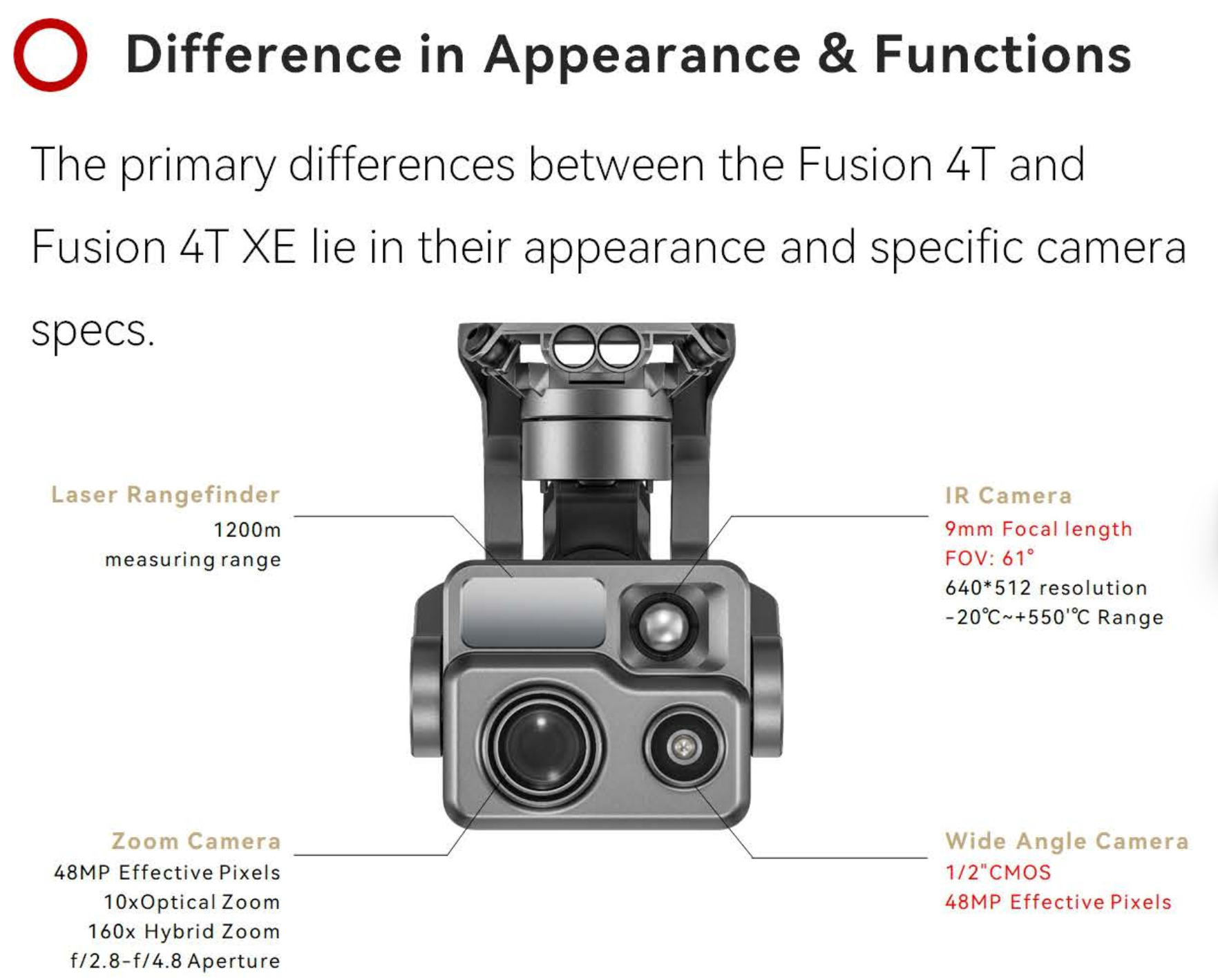
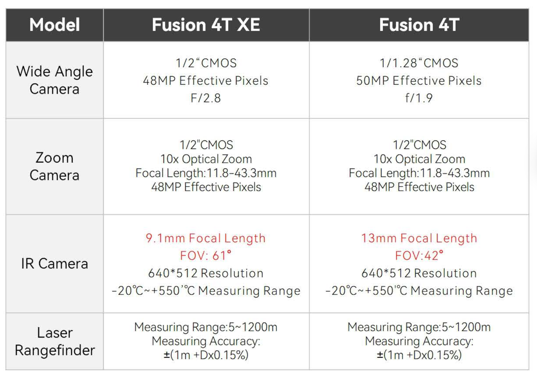
1/2" CMOS, Effective pixels: 48M |
|
Lens |
Focal length: 11.8-43.3mm (35mm, equivalent: 64-234mm) Aperture: f/2.8-f/4.8 |
|
Exposure Compensation |
±3EV 0.3EV/step |
|
ISO Range |
Normal Mode: Auto: ISO100 ~ ISO6400 Manual: Photo: ISO100 ~ ISO12800 Video: ISO100 ~ ISO6400 |
|
Shutter Speed |
Photo: 8s ~ 1/8000s Video: 1s ~ 1/8000s |
|
Max Photo Size |
8000×6000 |
|
Max Video Resolution |
7680×4320 |
Wide Camera
|
Sensor |
1/1/2" CMOS, Effective pixels: 48M |
|
Lens |
DFOV: 85° Focal length: 4.5 mm (equivalent: 23 mm) Aperture: f/2.8 |
|
Exposure Compensation |
±3EV 0.3EV/step |
|
ISO Range |
Auto: Photo: ISO100~ISO6400 Video: ISO100~ISO64000 (Night scene mode: up to ISO64000) Manual: Photo: ISO100~ISO12800 Video: ISO100~ISO6400 |
|
Shutter Speed |
Photo: 8s ~ 1/8000s Video: 1s ~ 1/8000s |
|
Max. Video Resolution |
3840×2160 |
|
Photo Size |
8192*6144 4096*3072 |
Thermal Camera
|
Thermal Imager |
Uncooled VOx Microbolometer |
|
Lens |
DFOV: 61° Aperture: 9.1mm Focus: f/1.2 |
|
Infrared Temperature Measurement Accuracy |
26.6~37.4 ℉ or reading ±3% (using the larger value) @ambient temperature -4℉ to 140℉ |
|
Video Resolution |
640*512 |
|
Photo Size |
640*512 |
|
Pixel Pitch |
12 um |
|
Temperature Measurement Method |
Center measurement, pot measurement, rectangular measurement |
|
Temperature Measurement Range |
-4℉ to 302℉, 32℉ to 1022℉ (-20°C to 150°C, 0 to 550°C) |
|
Temperature Alert |
High and low temperature alarm thresholds, reporting coordinates and temperature values |
Laser Range Finder
|
Measurement Accuracy |
±1m |
|
Measuring Range |
1.2km |
Image Transmission
|
Operating Frequency |
2.4G/5.2G*/5.8G/900MHz* *5.2GHz is only applicable for FCC, CE, and UKCA regions. 900MHz is only applicable for FCC regions. |
|
Max Transmission Distance (unobstructed, free of interference) |
20km(FCC), 8km(CE) |
|
Independent Networking |
Autel Smart Controller V3 |
|
Transmitter Power (EIRP) |
2.4GHz:<33dBm(FCC), <20dBm(CE/SRRC/MIC) 5.8GHz:<33dBm(FCC), <30dBm(SRRC), <14dBm(CE) 5.15-5.25GHz: < 23dBm(FCC/SRRC/MIC) |
Autonomy
|
Non-GPS Hovering and Manual Flight |
Indoor: Horizontal error ≤3cm (At least have texture at one direction) Outdoor: Daytime: Within 500m flight height, horizontal error < 0.01*height Night: Manual flight is controllable within 100m flight height |
|
Non-GPS Return-to-Home |
Within 500m flight height, horizontal error of Return-to-Home point < 30cm |
|
Automatic Obstacle Rerouting |
High Speed Obstacle Rerouting: Flight speed up to 20m/s when Min. safety distance to obstacle is 1.5m High Precision Obstacle Rerouting: Flight speed could reach 3m/s when Min. safety distance to obstacle is 0.5m |
|
Multi-target Recognition and Tracking |
Target identification types: people, vehicles, boats Number of targets detected: 64 Comprehensive recognition accuracy: > 85% |
Millimeter-wave Radar
|
Frequency |
60Ghz~64Ghz |
|
Size |
38*14*2mm |
|
Weight |
2g |
|
EIRP |
18dbm |
|
Distance Detection Range |
For Obstacle Avoidance:0.2m~100m For Height Measurement:0.05m~200m |
|
Ranging Accuracy |
For Obstacle Avoidance:0.1m For Height Measurement:0.02m |
|
Speed Measurement Range |
± 60m/s(4D Mode);±28m/s(3D Mode); |
|
Speed Measurement Accuracy |
≤1% |
|
Max. Tracking Target Number |
32 |
Visual Sensing System
| Obstacle Sensing Range | Forward/Upward/Downward/Backward/Sideward: 0.2~50m |
| FOV | Forward/Backward/Sideward: 60°(H),80°(V) Upward/Downward: 360°(H),190°(V) |
Autel Smart Controller V3
|
Screen |
7.9 inch, 2000nits max. brightness, 2048*1536 resolution |
|
External Battery |
Capacity: 5800mAh Voltage: 11.55V Battery Type: Li-on Energy: 67Wh Charing time: 120mins Intelligent Lithium Ion Battery |
|
Operating Time |
3 hours (Max. brightness) 4.5 hours (50% brightness) |
|
Max Transmission Distance (with interference) |
FCC: 20km CE: 8km |
|
IP Rating |
IP43 |
|
Storage |
128G |
|
GNSS |
GPS+GLONASS+Galileo+Beidou |
|
Operating Temperature |
-20℃ to 40℃ |
|
Wi-Fi Protocol |
WiFi Direct, Wi-Fi Display, 802.11a/b/g/n/ac Support 2 x 2 MIMO Wi-Fi |
|
Operating Frequency |
2.400 - 2.4835 GHz; 5.150 - 5.250GHz; 5.725 ‒ 5.850 GHz |
|
Transmitter Power (EIRP) |
2.400 - 2.4835 GHz FCC/CE:≤20dBm 5.150 - 5.250GHz FCC:≤17dBm 5.725 ‒ 5.850 GHz FCC:≤17dBm CE:≤14dBm |
Aircraft Battery
| Capacity | 8070mAh |
| Voltage | 14.88V |
| Battery Type | LiPo 4S |
| Energy | 120wh |
| Net Weight | 520g |
| Charging Temperature | 5ºC to 45ºC(When the temperature is lower than 10° C (50° F), the selfheating function will be automatically enabled. Charging in a low temperature may shorten the lifetime of the battery) |
| Hot Swap | Support |
Our on-line store is open 24/7 and we ship Monday through Thursday, excluding some holidays. Orders received for products without shipping restrictions on its product page will ship the same business day when received before 12:00 p.m. PST. Orders in high demand will have an estimated time listed on its product page and will ship according to the date listed.
Signature is required for most shipments.
*How long does it take for you to ship a product?*
This depends on your location, the method of shipping and the item you choose.
For in stock items inside the USA we typically ship by UPS and FedEx and for small items we ship by USPS. We typically ship items within 1-2 business days of the order for in stock shipment.
Ground Shipments can take up to 5 Business days from our Washington location. Express options are available by contacting us, but UPS and FedEx do NOT guarantee any shipments at this time.
If there are lithium batteries (most drones & ROVS), these cannot be shipped express.
USPS typically takes 2-3 business days for the smaller items by priority mail.
Special Order items can take time to arrive, but once they arrive we ship them out right away.
SHIPPING NOTES:
- Orders under $50 = $25 Ground Shipping & Handling
- Orders $50-499.99 = $20 Ground Shipping & Handling
- Orders $500 or higher = FREE Ground Shipping & Handling (USA Only)
- Alaska & Hawaii have unique shipping starting at $75
- Contact us for Express Shipping Options
- DHL & UPS Available for International Orders*
*International shipments are typically sent by DHL or UPS. Please note you are responsible for any customs fee, taxes and brokerage fees that may be due by importing an item into your country.
LEARN MORE BY VISITING SKYWATCH HERE
While not always legally required, having insurance to fly a drone is highly recommended for several reasons:
Why You Should Consider Drone Insurance:
- Liability Coverage:
- Protects you if your drone causes injury or property damage to others.
- Damage Protection:
- Covers repairs or replacement costs if your drone is damaged in an accident.
- Theft Protection:
- Provides coverage if your drone is stolen.
- Compliance:
- Some commercial operations and clients may require proof of insurance before allowing you to fly.
- Peace of Mind:
- Offers reassurance that you are financially protected against unforeseen incidents.
Types of Drone Insurance:
- Liability Insurance:
- Covers legal fees and damages if your drone causes injury or property damage.
- Hull Insurance:
- Covers physical damage to your drone.
- Covers physical damage to you sensor (separately from the drone)
- Personal Injury Insurance:
- Covers injuries to yourself or your team while operating the drone.
- Commercial Drone Insurance:
- For businesses, covering multiple drones and operators, including comprehensive coverage options.
Where to Get Drone Insurance:
- Specialized drone insurance providers
- General insurance companies with drone policies
- Aviation insurance companies
Legal Requirements:
- Check local regulations as requirements can vary by country and region.
- In the U.S., the FAA does not mandate drone insurance, but it’s advisable for all operators, especially for commercial use.
In summary, while insurance might not be legally required, it is a smart and responsible choice to protect yourself and others while flying a drone.
Check with your insurance provider to see if they cover the drone rental and flights. If they do not, we highly recommend that you have insurance when you are flying drones. We have found that Skywatch.ai offers some of the best options for Drone Insurance.
LEARN MORE BY VISITING SKYWATCH HERE
Frequently Asked Questions
Do we offer Financing? The short answer is YES we do!
To determine the best financing option, we need to determine if you are interested in a personal financing option or if you will be using a business to finance your purchase.
 BUSINESS OPTIONS:
We work with 2 different companies for financing. Each Organization has their own criteria for purchases. These Financing options are for US customers only.
-
BNC Financial
Specializes in equipment funding from $500 and up. Follow this link to to the the financing application. -
First Pacific Funding
Financing options from $5000 and up. Follow this link to go to the financing application. - APPROVE Commercial Financing. Add an item to your cart, then click on the APPROVE logo for an inline application on the right hand of your screen. Monthly Payments and rates vary depending on final terms.
https://financing.approvepayments.com/blue-skies-drone-shop
 PERSONAL OPTIONS:
- Affirm
Buy now, pay later without the fees. Affirm is the smartest way to pay over time. Shop pretty much anywhere and pay at your own pace without any fees, so you can get the things you love without breaking your budget.
Affirm is built into our website. Click on the product you are interested in purchasing, then click on the 'Pre-qualify now' link.
Click Here to see the details on how it works -
Shop Pay
This payment option works similar to Affirm. If you do not see the shop pay option on the product page, click on "More payment options.
The Look for the button.

